
Long-distance hiking
from hut to hut, in the midst of nature
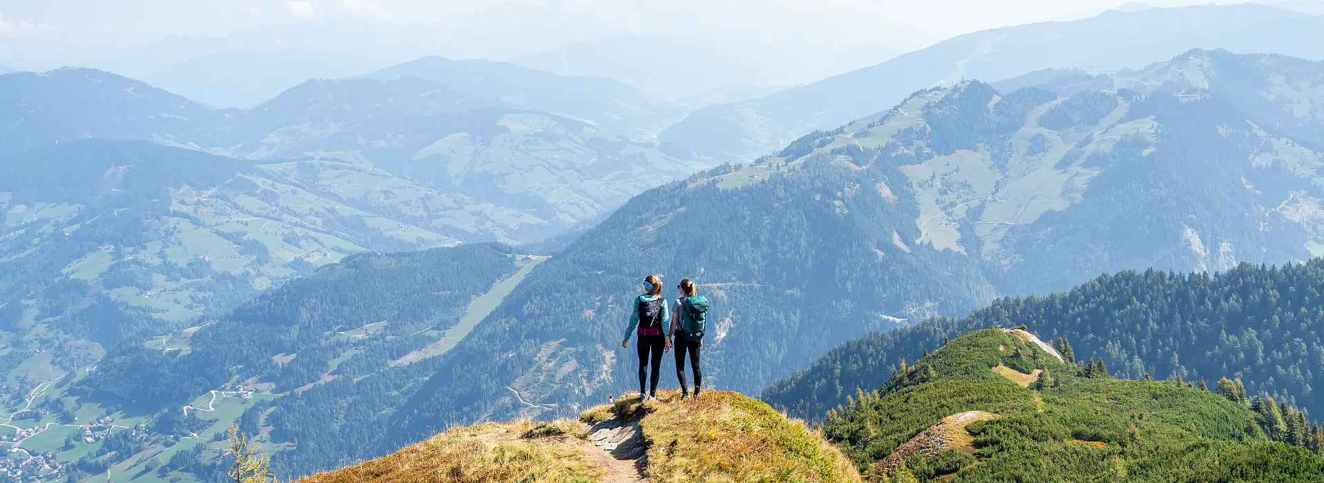
Do you enjoy hiking over idyllic alpine meadows and along trails through the forest to the high pastures and mountain huts of Grossarltal, completely in harmony with nature? In that case, we definitely recommend a multi-day hike in Grossarltal for your next hiking holiday.
Many of the huts in the Valley of Mountain Huts offer overnight accommodations, allowing for a wide selection of long-distance hiking opportunities. Experience the warm hospitality of your hut hosts. Get a firsthand look at the work involved in running a hill farm, reenergize, and find personal peace during a hut hike in Grossarltal.
The hiking taxis and hiking buses from Grossarltal are ideal for multi-day hikes, where they do not return to the starting point of the tour.
Contents


The Salzburger Almenweg is a long-distance hiking trail through the Salzburger Pongau region. Spanning 350 km, this trail includes 25 stages of varying lengths, leading to over 120 mountain huts. Long-distance hikers here enjoy the unique concentration of huts, quite unmatched in the Salzburger Pongau. No two huts are alike – and a good memory is a must, since each area of pastures and its hut have a different name. No matter where you go, however, you are warmly welcomed by your hut hosts and treated to homemade alpine specialties such as fresh milk, cheese, butter, yogurt, bread, bacon, and even home-distilled schnapps.
Along the Salzburger Almenweg, you are constantly accompanied by the image of the gentian, found on markers, benches, and near huts, ensuring you never lose sight of the trail.


Stages of the Salzburger Almenweg
Four of the total 25 stages of the Salzburger Almenweg lead through Grossarltal, making Grossarl and Hüttschlag ideal starting and finishing points for this long-distance trail.
The Salzburger Almenweg, coming from Bad Gastein, ascends to the Toferscharte. Hikers who are up for the challenge should definitely climb the Gamskarkogel – at 2,467 meters, it's the highest “grass mountain” in Europe.

Tip: For a special summit experience including an unparalleled sunrise and sunset, spend a night on the mountain. In fact, the Bad Gasteiner Hütte (Gamskarkogel Hut) is perched right on a summit. The trail then leads past the Harbachalm through the National Park Village of Hüttschlag, then via the Hallmoosalm up to the Karteisalm and Karteistörl.
After a short detour to the Tappenkarsee in Kleinarl, the Salzburger Almenweg continues up to the Draugsteintörl and back into Grossarltal. Then it leads you to the Draugsteinalmen, Filzmoossattel, Filzmoosalm, Loosbühelalm, Weissalm, Ellmaualm, Sonnseit-Almhütte, Grosswildalm, Breitenebenalm, Karseggalm, Unterwandalm, Maurachalm, and onwards to St. Johann-Alpendorf or Wagrain.
Alternatively, instead of hiking at the same elevation as the alpine pastures, you can also walk across the ridges and peaks, enjoying magnificent views of, for example, the Tappenkarsee or the surrounding mountains. You can drop back down to the valley from any of the mountain huts essentially whenever you wish.
After leaving Grossarltal, the Salzburger Almenweg continues via Wagrain and Kleinarl to Obertauern, Filzmoos, Werfenweng, the Hochkönig, across “Salzburg’s Sunny Terrace”, and finally through the Gasteinertal back to Grossarltal.


Salzburger Almenweg delicacies
Culinary delights on the Salzburger Almenweg
Along the Salzburger Almenweg you will pass many Grossarltal mountain huts, where you will be spoiled with traditional homemade delicacies. The animals' produce, such as the cows' milk, is usually processed into butter, cheese and curd directly on the mountain pasture. Since summer 2022, there have been designated “Almenweg Schmankerl” along the Salzburger Almenweg. These dishes are the flagships of the various mountain huts and guarantee you culinary variety on your long-distance hike.


Free Hiking Guide
Brochure of the Salzburger Almenweg
A complimentary hiking guide with detailed maps (scale 1:50,000) offers an in-depth description of the 25 stages along the Salzburger Almenweg.
We would be happy to send you the hiking guide for the Salzburger Almenweg.
Contents of the Hiking Guide:
- Starting point
- Trail surface
- Walking times
- Trail length
- Difficulty
- Route descriptions
- Refreshment opportunities
- Trail profiles
- Sightseeing tips

Uncover the "Grossarltal Hut Secrets" and create your own cookbook filled with hearty, savory, sweet, and "spirited" recipes from the mountain huts of Grossarltal.
At every mountain hut along the Salzburger Almenweg, within the municipalities of Grossarl and Hüttschlag, interested hikers will also receive a recipe – essentially the secret tips of the local hut hosts.
The selection of recipes includes "Muas," hearty main dishes like "Kasnock'n with Knetkäse" and "Bauernbratl with roasted potatoes," along with farmhouse-style donuts and the ever-popular "Schwarzbeernock'n." Of course, tips for delicious liqueurs using homemade schnapps are also included. With each hike to a hut on the Salzburger Almenweg, this recipe collection grows steadily into a small cookbook. You can collect the recipe cards in a handy, leather-strapped wooden folder.
This initiative brings the taste of the Salzburg Alpine Summer to the countless kitchens of Grossarltal’s guests. Try it for yourself! The back of the cards can also be used to jot down your fondest memories, turning this cookbook into your personal holiday diary!
The wooden folder is available at the Grossarltal Tourist Office for €8.00.

The Hohe Tauern Panorama Trail comprises 17 daily stages and is a long-distance hiking experience covering a route totaling 275 km. The trail traverses the holiday region of Hohe Tauern National Park in Salzburger Land, starting at Krimml Waterfalls and ending in the Valley of Mountain Huts, more specifically in the mountaineering village of Hüttschlag.
You are greeted by views of Austria's highest mountains and an array of fascinating natural spectacles, intriguing exhibitions, picturesque National Park towns, and attractive excursion destinations.
Tip: Mountain lifts and shuttles at each of the stage destinations, along with bookable luggage transfer service, guarantee maximum comfort and convenience for hikers.
Highlights of the Panorama Trail
- Hiking with breathtaking views at elevation between 1,500 and 2,400 meters
- 17 stages and 275 km of pure long-distance hiking experiences
- Stunning views of Austria's highest mountains
- Impressive start: Krimml Waterfalls
- Idyllic end: Mountaineering Village of Hüttschlag
- Overnight stays at mountain huts or accommodations in National Park towns
- Each stage features interesting exhibitions and attractive excursion destinations
Stage 17 in the Valley of Mountain Huts
Hohe Tauern Panorama Trail
Die letzte Etappe des Hohe Tauern Panorama Trails führt Sie in das ruhige und idyllische Großarltal. Die Wanderung startet in Bad Gastein und führt über die Poserhöhe auf die Tofernschafte ins ®Bergsteigerdorf Hüttschlag. Die aussichtsreiche Tagesetappe bietet noch einmal einen atemberaubenden Blick auf die Hohe Tauern bevor Sie die Wanderung ins Tal der Almen führt.
The final stage of the Hohe Tauern Panorama Trail leads you into tranquil and picturesque Grossarltal. The hike starts in Bad Gastein and leads over the Poserhöhe to the Tofernschafte, ending in the Mountaineering Village of Hüttschlag. This scenic day-stage offers one last breathtaking view of the Hohe Tauern before bringing you to our Valley of Mountain Huts.


